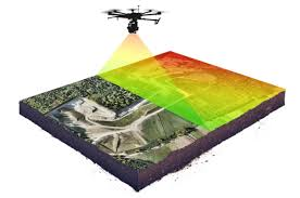
Mapping LIDAR sensor data is the process of using rapid laser pulses to measure distances and create highly detailed, three-dimensional representations of environments. The resulting data, known as a point cloud, provides precise positional and elevational information for both natural and man-made features.
How LiDAR Mapping Works
A LiDAR system typically consists of a laser scanner, a Global Positioning System (GPS), and an Inertial Navigation System (INS).
- Emission: The sensor emits millions of laser pulses per second toward a target.
- Reflection & Detection: The pulses reflect off objects (like ground, trees, or buildings) and return to the sensor.
- Distance Calculation: The system measures the “time of flight” (TOF) for each pulse’s return journey. Knowing the constant speed of light, it calculates the precise distance between the sensor and the target object (Distance = Speed of light x Time elapsed / 2).
- Positioning: The distance measurements are combined with the GPS location and INS orientation data (pitch, roll, and heading) of the sensor platform to determine the exact 3D coordinates (x, y, z) of each reflected point.
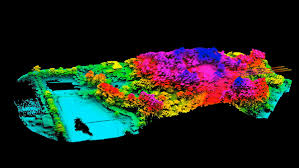
- Point Cloud Generation: These individual points form a massive dataset called a point cloud, which is the raw 3D map of the environment.
Key Data Products and Processing
Raw point cloud data is processed using specialized software to create usable map products.
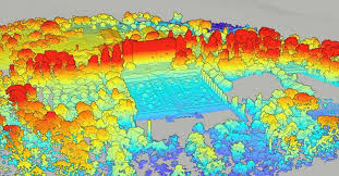
- Digital Surface Models (DSM): These models include all features on the Earth’s surface, such as buildings and vegetation.
- Digital Terrain Models (DTM): By filtering out objects and vegetation, DTMs show only the bare ground elevation, which is crucial for understanding the underlying topography.
- Digital Elevation Models (DEM): A general term for high-resolution models of ground elevation.
Processing involves steps like data filtering, cleaning, and point cloud classification (e.g., identifying points as ground, building, or vegetation). Techniques like Simultaneous Localization and Mapping (SLAM) or point cloud registration algorithms (e.g., ICP) are used to align successive scans and correct for drift to build large, seamless maps.
Primary Applications
LiDAR mapping offers unparalleled accuracy and efficiency across various fields.
- Topographic Mapping & Surveying: Creates highly detailed 3D maps and models of terrain for construction, infrastructure design, and land management.
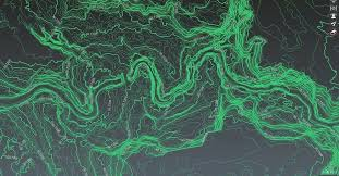
- Environmental Monitoring: Helps monitor forests, coastal erosion, and habitats by measuring vegetation density and land cover changes over time.
- Urban Planning: Provides precise measurements of existing infrastructure and landforms for smarter city design and managing growth.
- Autonomous Systems: Essential for self-driving vehicles and robotics to “see” and navigate their environment in real time.
- Disaster Management: Enables accurate flood modeling, landslide risk assessment, and rapid damage identification after events.
- Archaeology: Reveals hidden structures and ancient landscapes obscured by vegetation.
For US data, you can access Lidar data from the USGS National Map or NOAA’s Data Access Viewer.
AI responses may include
- What is LiDAR mapping – and how can you use it? – LuxCarta16 Oct 2023 — What is LiDAR mapping – and how can it be combined with other geospatial data? Unlock the power of LiDAR mapping: Disco…
LuxCarta
- Mastering LiDAR with DJI Enterprise: An Introductory Booklet17 Jan 2024 — What is LiDAR? LiDAR, which stands for Light Detection and Ranging, is a remote sensing technology that uses rapid lase…
DJI
- What is lidar data? – ArcMap Resources for ArcGIS DesktopLidar produces mass point cloud datasets that can be managed, visualized, analyzed, and shared using ArcGIS. The major hardware co…
Esri
- What is Lidar data and where can I download it? – USGS.gov12 May 2025 — Light Detection and Ranging (lidar) is a technology used to create high-resolution models of ground elevation with a ve…
USGS (.gov)
- Introduction to Lidar – MATLAB & Simulink – MathWorksWhat Is a Point Cloud? A point cloud is a collection of 3-D points in space. Just as an image is the output of a camera, a point c…
MathWorks
- Lidar Applications in the Modern World – Fugro30 Jun 2025 — Lidar applications in the modern world. … Lidar technology has transformed how we map and understand the world around…
Fugro
- LiDAR Data Processing: Deliverables,and Key Steps14 Oct 2024 — Frequently Asked Questions * What is LiDAR data processing? LiDAR processing translates raw point cloud data into accur…
YellowScan
- Using LiDAR layers for landscape research – Map images14 Jan 2025 — Using LiDAR layers for landscape research. … Light Detection and Ranging (LiDAR) is an airborne mapping technique, wh…
National Library of Scotland
- LiDAR Finder* LiDAR is a technology which uses laser light to create a 3D representation of the earth’s surface. It can be used to find archae…
LiDAR Finder
- The Ultimate Guide to LiDAR Drone Mapping for Professional Pilots8 Apr 2025 — Top Applications of LiDAR Mapping Drones. … Here’s how LiDAR drones shine in real-world jobs: * Construction and Land …
SPH Engineering
- Build a Map from Lidar Data – MATLAB & Simulink – MathWorksEach scan of lidar data is stored as a 3-D point cloud using the pointCloud object. This object internally organizes the data usin…
mathworks.cn
- LiDAR: What Is It and How Does It Work? – YellowScanLiDAR principle is pretty easy to understand: * it emits a laser pulse on a surface. * catches the reflected laser back to the LiD…
YellowScan
- LiDAR Data Stitching: How to Improve SLAM with Precision Location11 Aug 2024 — What is SLAM LiDAR? * LiDAR (Light Detection and Ranging) is a remote sensing technology that uses laser light to measu…
Point One Navigation
- What is Lidar Mapping? – Mindkosh AI2 Oct 2024 — What is Lidar Mapping? Lidar mapping uses laser scans to create accurate 3D maps of the earth’s surface. In this blog, w…
Mindkosh
- What Is Lidar and How Does It Work? | ARTICLE | FAROHow Do Lidar Sensors Work? Depending on the LIDAR sensor, scanners can emit millions of laser pulses per second. Each pulse return…
FARO.com
- Everything you need to know about Lidar point clouds – Mindkosh AI4 Aug 2024 — What is a lidar sensor? Lidar has revolutionized the way we gather and analyze data about our surroundings. Lidar sensor…
Mindkosh
- NOAA: Data Access Viewer25 Sept 2025 — The Data Access Viewer (DAV) allows a user to search for and download elevation (lidar), imagery, and land cover data …
NOAA Office for Coastal Management (.gov)
- LiDAR and Drones: A New Era in Topographical Mapping & Surveying Data Processing with Specialized Software: Use specialized software like DJI Terra to process the collected LiDAR data.
Advexure
- The Utility of Lidar: Mapping Risk, Planning Smarter, and Protecting23 Apr 2025 — Wind Energy. Lidar helps identify ideal locations for wind farms by mapping the topography in detail. By mapping hills,
OpenTopography